There is a town on the California coast that is so reclusive you will find no highway signs pointing the way. Some years ago I read an article about the town that piqued my interest and made me want to go there even more than usual. Bolinas is not on any main highway, secondary highway or even any throughway--it sits on a peninsula at the very end of a small, unmarked, unremarkable country road somewhere north of San Francisco and west of Sausalito.

If you study a map of the California coast with a magnifying glass you will find it--and if you didn't know better you would dismiss it as too small and not worth the time or trouble.

As I crossed Mt Tamalpais from Sausalito and headed down toward the ocean I encountered a major fog bank. It gave the approach to the town an eerie, other-world feel--right out of a Stephen King novel.

What intrigued me about this town is that the residents have removed and destroyed so many signs leading to their town that the state finally agreed that no more signs would be put on the highways. This is one town that does not want a bunch of tourists cluttering it up. So naturally, I had to go there.

If you study a map of the California coast with a magnifying glass you will find it--and if you didn't know better you would dismiss it as too small and not worth the time or trouble.

As I crossed Mt Tamalpais from Sausalito and headed down toward the ocean I encountered a major fog bank. It gave the approach to the town an eerie, other-world feel--right out of a Stephen King novel.

What intrigued me about this town is that the residents have removed and destroyed so many signs leading to their town that the state finally agreed that no more signs would be put on the highways. This is one town that does not want a bunch of tourists cluttering it up. So naturally, I had to go there.

At least Elizabeth, the GPS knew which way to turn--otherwise I am not sure I would have selected the right direction.

This was the only identification--already I was glad I had come.

But just as I was beginning to think the welcome might be a little strained I started meeting some really nice people, who had time to visit with me and tell me about their unusual community.

One shopkeeper offered her yard if I wanted to spend the night and I was tempted but I declined the offer.

The homes were charming with lots of courtyards, patios,

and nice places to sit and visit with one's neighbors.


As I walked I began to notice that the small inlet from the bay was losing its water...

All the houses on the bay side were on stilts with porches over the water. One resident told me everyone there is especially mindful of the tides and have to time their fishing trips accordingly.

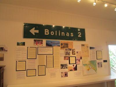
And then I found their little museum,

Here were the road signs that had been purloined over the years.

The museum was directly across the street from these houses sitting on the bay and I could look out the door and see this view. When I read the following notice I realized I had traveled even further than originally thought:
YOU ARE NO LONGER ON THE NORTH AMERICAN CONTINENT.
This is a landscape of remarkable geology. Where you stand now, turn and look out the door at the hills. They are the edge of the North American tectonic plate. You are now standing on the Pacific Tectonic plate. We are on the Point Reyes Peninsula which is an island of land that has been moving northward for millions of years. The lagoon is the San Andreas Fault, the actual division of two great tectonic plates.
I left the continent and didn't even need a passport.


Did you get to Bodega Bay? It is also a "hidden" town.
ReplyDelete